
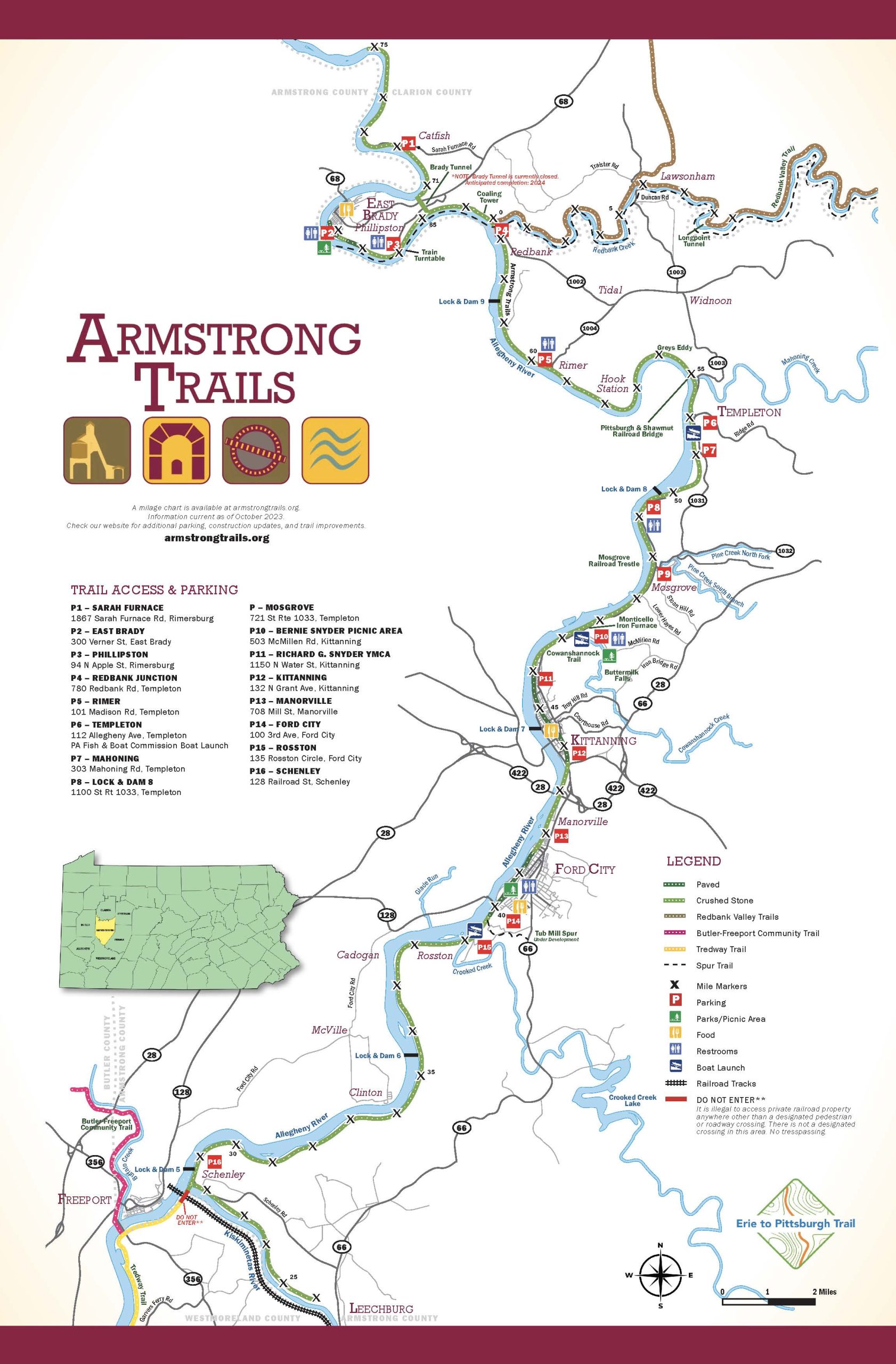
How To Read Our Maps
MP or Mile Posts are often referenced along Armstrong Trails. MP indicated miles from Pittsburgh. Example, our Rosston Parking area is near MP 39.1, Lock & Dam 9 is near MP 61, East Brady MP 68 and the northern side of the Brady Tunnel is MP 71. So, how is East Brady MP 68 and through the tunnel is MP 71. The explanation is simple and also a history lesson. Allegheny Valley Railroad was finished in 1852. After many years of servicing Brady’s Bend Iron, the railroad was determined to find a shorter route and that is when the Brady Tunnel came in to play. Brady Tunnel construction began in 1913 and was opened on 1916. Using the tunnel, as their new route saved the railroad over 5-miles in travel, those 5-miles of corridor were haunted with land-slides, narrow corridor and time. The corridor does not, nor ever will travel through East Brady due to those reasons and is now owned by several landowners. Please do not access the northern end of the tunnel by riding through East Brady. Be respectful of our neighbors.
Trailheads and Parking
15 of 15 trail locations shown.
Trailhead & parking directory
Browse every location below. Directions open Google Maps, where you can choose driving, walking, or cycling. Use the downloadable trail map for the trail route itself.
Bernie Snyder Picnic Area
503 McMillen Rd., Kittanning/Buttermilk Falls
40.8507,-79.5072
MP 47.5
Parking, Restrooms, Kayak
Amenities: Trailhead, Parking, Restrooms, Kayak
Get directions to Bernie Snyder Picnic Area (opens Google Maps)
Coordinates: 40.8507, -79.5072
East Brady Parking
300 Verner St., East Brady
40.9786,-79.6186
MP 67.6
Parking, Restrooms
Amenities: Trailhead, Parking, Restrooms
Get directions to East Brady Parking (opens Google Maps)
Coordinates: 40.9786, -79.6186
Ford City Parking
100 3rd Ave., Ford City
40.7614,-79.5409
MP 40
Parking, Restroom, Food
Amenities: Trailhead, Parking, Food, Restrooms
Get directions to Ford City Parking (opens Google Maps)
Coordinates: 40.7614, -79.5409
Lock 8 Parking
1100 St. Rte. 1033
40.8941,-79.4769
MP 51.5
Parking, Restrooms
Amenities: Trailhead, Parking, Restrooms
Get directions to Lock 8 Parking (opens Google Maps)
Coordinates: 40.8941, -79.4769
Mahoning Creek Parking
303 Mahoning Rd, Templeton
40.9338,-79.4617
MP 54.7
Parking
Amenities: Trailhead, Parking
Get directions to Mahoning Creek Parking (opens Google Maps)
Coordinates: 40.9338, -79.4617
Manorville
708 Mill St, Manorville
40.7881,-79.5195
MP 42
Parking, Bike Fix-It-Station
Amenities: Trailhead, Parking, Bike Repair
Get directions to Manorville (opens Google Maps)
Coordinates: 40.7881, -79.5195
Market Street
402 Market Street, Kittanning
40.8328,-79.5292
MP44.5
Parking, Restrooms, Food
Amenities: Trailhead, Parking, Food, Restrooms
Get directions to Market Street (opens Google Maps)
Coordinates: 40.8328, -79.5292
Mosgrove Parking
721 St. Rte 1033, Templeton
40.9195,-79.4630
MP 48
Parking, Kayak
Amenities: Trailhead, Parking, Kayak
Get directions to Mosgrove Parking (opens Google Maps)
Coordinates: 40.9195, -79.463
Phillipston Turntable Parking
94 N. Apple St., Rimersburg
40.9751,-79.5894
MP 66
Parking, Restrooms
Amenities: Trailhead, Parking, Restrooms
Get directions to Phillipston Turntable Parking (opens Google Maps)
Coordinates: 40.9751, -79.5894
Redbank Junction Parking
780 Redbank Rd., Templeton
40.9813,-79.5489
MP 63.2
Parking
Amenities: Trailhead, Parking
Get directions to Redbank Junction Parking (opens Google Maps)
Coordinates: 40.9813, -79.5489
Richard G. Snyder YMCA
1150 N. Water St.
40.8268/-79.5270
MP 45.5
Parking, Restrooms, Food
Amenities: Trailhead, Parking, Food, Restrooms
Get directions to Richard G. Snyder YMCA (opens Google Maps)
Coordinates: 40.8268, -79.527
Rimer Parking
101 Madison Rd., Templeton
40.9349,-79.5236
MP 59.4
Parking, Kayak
Amenities: Trailhead, Parking, Kayak
Get directions to Rimer Parking (opens Google Maps)
Coordinates: 40.9349, -79.5236
Rosston Boat Launch
135 Rosston Circle, Ford City
40.7492,-79.5539
MP 39.1
Parking, Kayak (PA Fish & Boat Launch)
Amenities: Trailhead, Parking, Kayak
Get directions to Rosston Boat Launch (opens Google Maps)
Coordinates: 40.7492, -79.5539
Sarah Furnace Parking
1867 Sarah Furnace Rd., Rimersburg
41.0065,-79.5866
MP 71.7
Parking
Amenities: Trailhead, Parking
Get directions to Sarah Furnace Parking (opens Google Maps)
Coordinates: 41.0065, -79.5866
Templeton Boat Launch
112 Allegheny Ave., Templeton
40.9192,-79.4633
MP 53.7
Parking, Restrooms, Kayak (PA Fish & Boat Launch)
Amenities: Trailhead, Parking, Restrooms, Kayak
Get directions to Templeton Boat Launch (opens Google Maps)
Coordinates: 40.9192, -79.4633

